The Podkarpackie Voivodeship, which is located in southeastern Poland, is one of the easternmost regions of the European Union. It borders with such countries as Ukraine and Slovakia as well as with małopolskie, świętokrzyskie and lubelskie voivodships. It is a region with a rich history, extremely valuable nature and full of wonderful monuments.
Capital city of the voivodeship: Rzeszów
Area: 17 846 km² (5,7 % of Poland's territory)
Population: around 2129000 (5,5 % of the country's population)
Length of borders: 906 km:
- 131 km with Slovakia,
- 235 km with Ukraine (eastern border of the European Union),
- 177 km with the Małopolska voivodeship,
- 282 km with the Lubelskie voivodeship,
- 81 km with the Świętokrzyskie voivodeship.
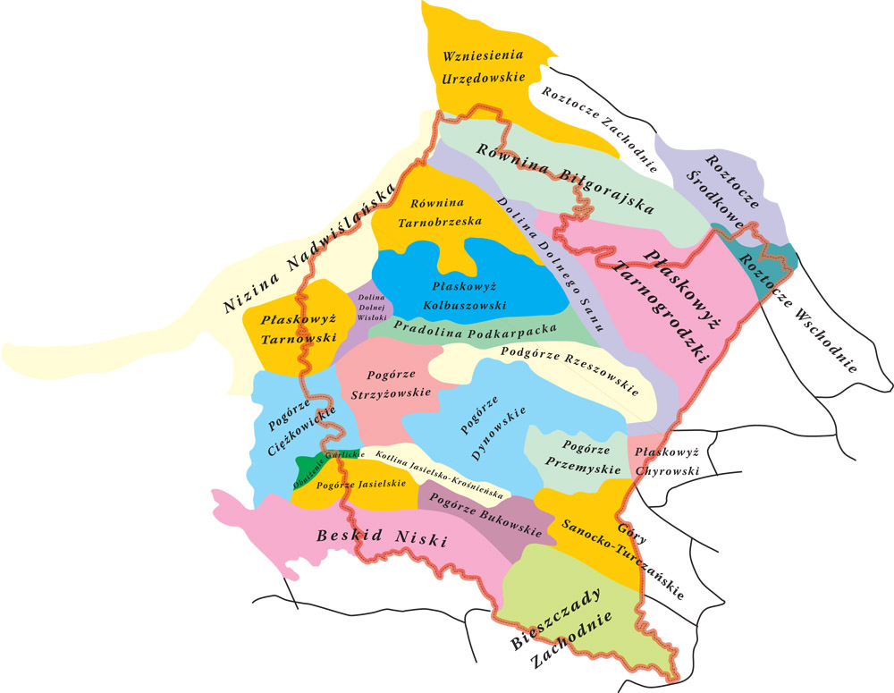
In accordance with the commonly accepted physico-geographical division established by Professor Jerzy Kondracki, almost the entire area of the voivodeship is located in the Western Carpathians province with the Western and Northern Podkarpacie. This province is divided into two subprovinces: Northern Podkarpacie and Outer Western Carpathians. The Northern Podkarpacie includes the Sandomierz Basin macroregion, whereas the Western Carpathian subprovince includes the Central Beskid Foothills and the Central Beskid Mountains macroregion (the area of the Beskid Niski Mountains). The eastern part of the region belongs to the Eastern Carpathians province with the Eastern Podkarpacie dividing again into two subprovinces: Eastern Beskids (these are the Bieszczady Mountains and the Sanocko-Turczańskie Mountains) and Eastern Podkarpacie(a small fragment of the Sańsko-Dniestrzański Plateau macroregion south of Przemyśl). The northern part of the voivodship is situated in the Polish Uplands province, which includes the Lublin-Lviv Upland subprovince. Part of the latter in the Podkarpackie province is a fragment of the Roztocze macro-region (Southern Roztocze and part of Middle Roztocze). Macroregions are divided into mesoregions which are shown on the map.
In a nutshell, the area of Podkarpackie voivodeship is divided into a fragment of Roztocze, the Sandomierz Basin and the Carpathians. Beskid Niski and the Foothills belong to the Western Carpathians, while the Bieszczady and the Sanocko-Turczańskie Mountains are part of the Eastern Carpathians. The physico-geographical division does not always agree with the geobotanical one. The most significant difference in Podkarpackie is the location of Przemyskie Foothills. According to Kondracki Pogórze Przemyskie belongs to the Western Carpathians.